Early Surveys in Washington
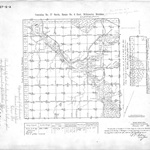
The official surveys of Washington and Oregon, then simply know as the Oregon Territory, began in 1851 on a hill just west of Portland. The initial point for all surveys of Washington and Oregon marked the intersection of the east-west base line and the north-south meridian of the Willamette Meridian. Every property in Washington is referenced to this initial point. The first Surveyor General of the United States Government Land Office for the Oregon Territory began his surveys from that point. Over the decades all of Washington and Oregon was surveyed on a rectangular grid system called "townships". A township is 36 square miles, being 6 miles on a side. The square mile sections are numbered from 1 to 36 starting in the northeast corner of the township and are numbered from east to west and west to east in tiers ending at section 36 in the southeast corner of the section. Government Surveyors first began by surveying the base lines and meridians setting monument posts every half mile. Later, contracts were issued for the surveys of township exteriors. Next, contracts were issued for surveys of the individual sections in each township. In all cases, monuments were placed every half mile on the exteriors of every section. With this system, a tract of land could be uniquely described in terms of its distance from the initial point. For example, Farmer Jones might settle on and purchase 240 acres in the Northwest quarter of Section 16, Township 30 North, Range 5 East, W.M. Section 16 is just about in the middle of the township which begins 174 miles north and 24 miles east of the initial point. Monuments were clearly marked and bearing trees blazed so that settlers could identify their tract of land.
Surveying these lines in the mid 1800’s to early 1900’s was difficult and sometimes dangerous work. There were no highways or bridges, very few roads and some trails in the territory at the time. The survey parties had to haul their survey equipment, camp equipment and supplies through whatever wilderness terrain they came upon. Although the tribes in the northwest were generally peaceful, the early surveyors sometimes had run-ins with the native peoples which were not all pleasant. Grizzly bears and cougars still roamed the Washington wilderness back then. Crews had to clear the lines to achieve line of sight and to measure the distances mile after mile. All but the largest trees were cut down. Lines were run through heavy virgin forest, over rivers, and through the mountains. The survey measurements were made primarily with a transit with solar attachment and a 66 foot long gunter’s chain. To determine geodetic north, the survey took solar and celestial observations.
Today, we perpetuate and preserve the positions these early surveyors established with their first monuments. Many of our roads run along section lines and the section corner positions have been restored with modern monuments placed in iron casings in the roadway. In other cases, these monuments are along property lines and cannot be accessed without the modern surveyor crossing private land. Some landowners don’t understand that these monuments are the key to the location of property boundaries for a large area surrounding them. Typically, a single monument can be crucial in helping determine the boundaries of properties in a one to two square mile area. Sadly, many have been destroyed.
Our technology is far advanced from the early surveyors. We use electronic distance and angle measurement, Global Positioning and electronic data collection. Computers in the office process the data and color plotters print the finished maps. But, with all the technology, we still rely upon and respect the work of the early surveyors. This is called “following in the footsteps” and it is why you will sometimes see us diligently searching for evidence of earlier survey work in some obscure place. That evidence is the foundation for our system of land ownership today and is essential in determining the location of boundaries.
If you have any questions or stories to share please feel free to contact Skip Walton. He can be reached by phone at 360-794-7811 or by e-mail at skipw@harmseninc.com.
|
Gallery: Early Surveying
| 
Survey Transit
Early transit used for surveying
| 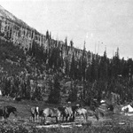
Survey Camp
Survey camp in Washington State around 1914
| 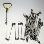
Gunter's Chain
Surveyor's gunter chain used for measurements
|
|